
Hiking in the Tarentaise Valley and Maurienne Valley, French Alps
 There are some spectacular hikes in the Alps with dramatic alpine scenery and unspoilt breathtaking landscapes.
This post focuses on Hiking the Tarentaise Valley and Maurienne Valley.
Both valleys offer trails for families, routes for hikers and some that are for the more devoted.
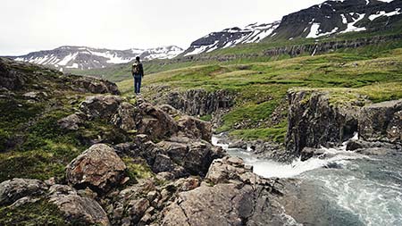
Vanoise National Park
The Vanoise National Park is located in the French département of Savoie (in the Rhône-Alpes region). The Park is a wide open space between the Tarentaise Valley and the Maurienne Vallery that you can use freely – with respect. It is the biggest protected area in the western French Alps with over 600km of footpaths inside the park.
Rules of the park: stick to the trails. Visitors and people who live here have a duty to respect the area and leave behind no trace. Take all your rubbish with you and please do not pick or collect flowers, fruit, insects or minerals.
The Park can be reached from Modane to the south (access to the Maurienne area), from Bourg Saint Maurice to the north (access to the Haute Tarentaise area) and or Moûtiers to the west (access to the Tarentaise area). The Italian border is located to the east, with 14 km of border shared with the Italian Gran Paradiso National Park.
Click here to see the area on google Maps
In the summer in the Vanoise National Park you can find an abundance of wildlife such as marmots, ibexes, chamois, the Royal eagle, black grouse, the great horned owl, the tridactyl woodpecker, the blue thistle, linneus borealis or the Piedmont primrose.
Footpaths inside the Vanoise National Park
Exploring the Vanoise National Park
Hikers seeking mountain accommodation
Hiking in the Vanoise National Park
The Park is crossed by some major hiking routes:
The GR® 5 hiking trail – 10 days in the Vanoise National Park
The GR®5 is also known as the European long-distance hiking trail (E2). Some 2500 kilometres long the GR®5 starts in the Netherlands and finishes in Nice. It crosses the Ardennes, the plateau in the Lorraine region, the Vosges mountains, the plateaux and gorges of the Jura, ending up in the Alps and the Vanoise National Park (from Peisey-Nancroix to Modane).
The GR® 55 hiking trail – 7 days in the Vanoise National Park
The GR® 55 trail is a “High Mountain” version of the GR® 5. The GR® 55 the GR® 5 in Tignes and joins it again in Modane (for the stage to up Thabor mountain to the refuge just outside the park) via Pralognan-la-Vanoise.
Beautiful views and permanent snow fields can be seen at the col de la Leisse (2,758 m) and the col de Chavière (2,796 m).
Via Alpina / Red trail – 7 days in the Vanoise National Park
The red trail is a route linking the eight Alpine countries of Italy, Slovenia, Austria, Germany, Liechtenstein, Switzerland, France, and Monaco. It crosses the main chain of the Alps several times, linking Trieste to Monaco and Bavaria to Liechtenstein.
Tarentaise valley
The Tarentaise Valley is a valley created by the Isère River in the heart of the French Alps. Famous for it’s ski resorts from Val Thorens to Val D’Isere, the forests in the Valley are also riddled with hiking trails.
Hiking the Paradiski area in the summer
The Paradiski area includes the villages of Vallandry, Plan-Peisey, Peisey-Nancroix, Landry, Bourg st Maurice, Arc 1600, Arc 1800, Arc 1950, Arc 2000 (Les Arcs), Villaroger, Plagne 1800, Plagne Centre, Plagne Aime 2000, Plagne Villages, Plagne Soleil, Plagne Bellecôte, Belle Plagne, Montchavin-les-Coches, Plan Montalbert, Champagny en Vanoise.
Overall the Paradiski area offers over 500km of marked hiking/walking routes on an over all of 6700m gradients.
The Vanoise Express ski-lift links La Plagne to Peisey-Vallandry and is open in July and August for those who want to use the whole resort. Between these months the chair lifts are also open for those who would like to take a more relaxed journey.
Vallandry, Plan-Peisey, Peisey-Nancroix and Landry sit on the north side of the Vanoise National Park and give direct access to the GR®5.
The Maurienne valley
The Maurienne Valley was the old passage between France and Italy, running from east of Chambéry to the ‘Arc’ water springs and glaciers just past Bonneval.
Haute Maurienne Vanoise, villages
Bonneval-sur-Arc 1800 M
Méan Martin and Grand Roc Noir tour – Hike starting from Bonneval-sur-Arc – 4 days
One of France’s most beautiful villages; stone houses with stone-slab roofs.
Bessans 1750 M
Bessanèse tour (between France and Italy) – Hike starting from Bessans – 5 days
Bessans offers a large network of hiking trails between the Vanoise National Park, the Avérole valley and the wilderness of Ribon valley.
The village itself is characterised by rich heritage where you will find wall paintings, Baroque chapels, engraved stones and artisan sculptors. The legend of the Devil of Bessans characterises the originality of this traditional culture, which is still alive today.
Val Cenis 1400 – 2800 M
The two french villages of Val Cenis Lanslebourg and Val Cenis Lanslevillard have a balance of modern and traditional, nature and man made. Discover extensive Baroque heritage and 12 restored chapels. Or make the most of the many shops, crafts and activities.
The Mont-Cenis pass links France to Italy, where there is a large turquoise Alpine lake, the pyramid museum and Alpine garden. The pass was an invasion route built by Napoleon I in 1803–10.
Sollières-Sardières 1300 – 1500 M
Set on the south side of the Vanoise National Park, Sollières-Sardières is a village made up of 3 preserved hamlets. A 93-metre high monolith protects the village. On the west of the river, stretches l’Endroit, a mountain plateau.
There is plenty of hiking among the plains, glades and forests of the Vanoise National Park.
There is an archaeology museum that traces 6000 years of history in the Maurienne mountains and uncovers the Neolithic past of Sollières-Sardières.
Bramans Val D’Ambin 1250 – 1800 M
Bramans Val D’Ambion is perfectly situated at the crossroads of the GR®5, Tour de Maurienne or the Grandes Alpes route.
When walking or hiking please take all your rubbish with you.